
Editor’s Note: A version of this article originally appeared in the weekly weather newsletter, the CNN Weather Brief, which is released every Monday. You can sign up here to receive them every week and during significant storms.
If you follow seasons by the meteorological calendar, we are halfway through spring, but if you look at the forecast this week, it seems like anything but. A huge spring chill will impact a large chunk of the country this week, dropping temperatures well below normal and even bringing the potential for a handful of record lows.
“After 4 consecutive days with temperature departures of +20 to +30F mid-month, the stagnant cool pattern of late should mean April ends below normal for most,” the National Weather Service office in the Twin Cities said, speaking about the Upper Midwest.
Monday morning, Indianapolis tied a record low temperature after a morning start of just 28 degrees. Just four days ago, Indianapolis nearly tied a record high temperature, missing it by only 1 degree.
Many cities are bracing for a similar swing in temperature extremes in the coming days.
The cold will spread south and east this week, where millions could see temperatures well below normal from the Upper Midwest to the South. Temperatures will be running 10 to 20 degrees below normal, potentially breaking a few low temperature records the first half of the week.
The cold will spill pretty far south, affecting places from Texas to the East Coast. Asheville, North Carolina, could break a record low Tuesday morning if they get below freezing. The Tri-Cities area of Tennessee could also break a record low Tuesday morning.
Temperatures will dip well below freezing across the Ohio Valley, which could kill crops and other vegetation.
“It appears Wednesday night has the best shot for rather cold temperatures to occur. Lows could be quite damaging to tender vegetation in the middle 20s in the extreme east and lower 30s elsewhere,” the weather service office in Cleveland warned.
Even parts of Georgia and the Gulf Coast states will dip close to freezing, as the big chill stretches as far south as the Gulf Coast.
For parts of the northern tier and Midwest tired of the cold, and ready for the warmth of spring and summer, the cooler temps are having a beneficial impact on the region by slowing the inevitable flooding from snowmelt.
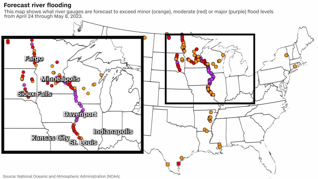
Major river flooding expands across the Midwest
The spring snowmelt is well underway, leading to major flooding across the Upper Midwest and along the Mississippi River. We talked about this occurring back in March, and now it is actually happening.

WWN24 Weather
This week, cities along the Mississippi River from Minneapolis to Burlington, Iowa, could experience flooding as more than 30 river gauges reach major flood stage. Unlike flash flooding, which occurs very rapidly, this is seasonal, spring river flooding, which is occurring rather gradually as record to near record snowpack across the Upper Midwest melts.
This winter several cities in the Upper Midwest saw exceptional snowfall:
- Duluth, Minnesota, broke its highest seasonal snowfall record last week
- Minneapolis is currently sitting at its third-highest season snowfall
- And Madison, Wisconsin, is sitting at eighth for the season
Additional snowmelt across the Upper Midwest is expected to add more water to the rivers and streams this week. With forecast temperatures at or below average and minimal rainfall where snow is still on the ground, melting is expected to remain gradual.
Cities experiencing flood effects this week and into the weekend include Minneapolis-St. Paul; Winona, Minnesota; La Crosse, Wisconsin; and McGregor, Dubuque and Davenport in Iowa. Riverside parks and city streets are expected to become submerged in floodwater.
The river flooding will continue to move downstream along the Mississippi River as we move into May.
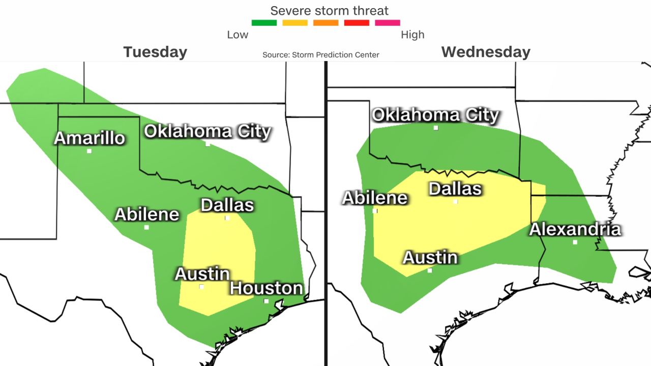
Severe storms and flooding set to impact millions across the South
Severe weather will start ramping up Tuesday and Wednesday across the South. While damaging winds and hail will be the main threats, tornadoes can’t be ruled out.
WWN24 Weather
On Tuesday, the Storm Prediction Center highlighted an area encompassing nearly 10 million people in Texas. Places like Dallas-Fort Worth are included in what the storm center has labeled as having a Level 2 of 5 “slight risk” of severe weather.
“At this juncture, it appears Tuesday could end up being more of a low-coverage but high-impact day,
perhaps with only a few storms but a higher-end threat potential,” the weather service office in Fort Worth said.
There is a broader risk of severe weather stretching into Oklahoma, along with portions of southern Colorado and New Mexico. The Level 1 risk area includes San Antonio, Houston and Oklahoma City. Areas hit hard last week in Oklahoma from tornadoes, could experience strong storms once again.

See aftermath of deadly tornado devastating Oklahoma
Despite the uncertainty in how the severe weather will unfold, “all severe hazards are possible,” the weather service office in Norman, Oklahoma, warned.
By Wednesday, the severe threat broadens, still including many of the same areas from Tuesday. More than 10 million people are covered by Wednesday’s Level 2 risk for severe weather, including the Dallas-Fort Worth metroplex. A Level 1 risk extends to the north and south including places like San Antonio, Austin and Oklahoma City.
CNN Weather
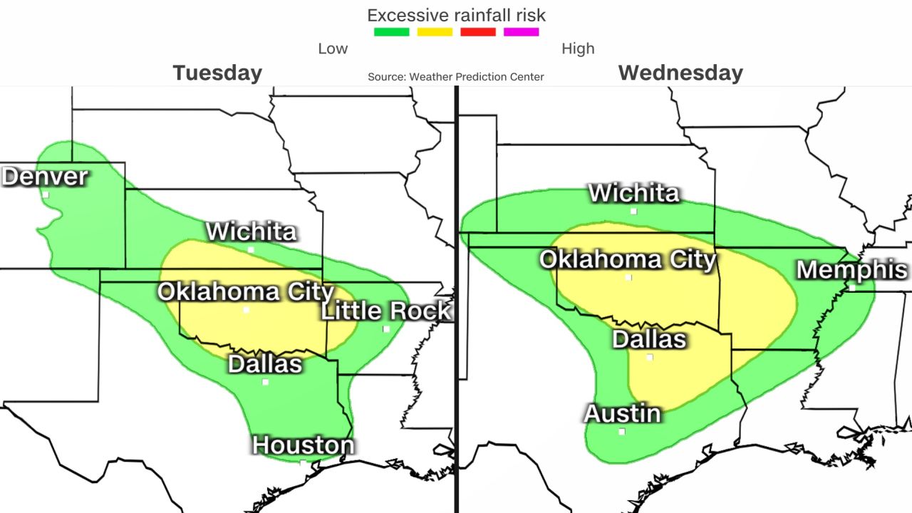
The threat of flash flooding will also be a concern. The Weather Prediction Center has issued a Level 2 of 4 “slight risk” of excessive rainfall for Tuesday and Wednesday, mostly overlapping the areas with severe potential.
“Multiple rounds of heavier rain are expected Tuesday into Wednesday which will bring a slight risk for flooding,” the weather service office in Norman, Oklahoma, warned in a tweet.
The area could see up to four inches of rain through Wednesday.
By the second half of the week, the severe weather and flash flood threat should be winding down across the midsection of the country.